Dec 18, 2016 at Coyote Ridge Trail: Stevens Creek County Park/Fremont Older Open Space Preserve

Stats of Hike:
Distance ~3.1 miles out-and-back
Elevation Profile:
Max Elevation 1001 ft
Min Elevation 440 ft
Difference: +561 ft
Difficulty: Moderate
Comments on Difficulty: This has a large/considerable elevation gain; fast forward to 2019 I actually ran this hill on a 7 mile run with my high school :-) It was tough in the start, but not so bad later on.
Difficulty: Moderate
Comments on Difficulty: This has a large/considerable elevation gain; fast forward to 2019 I actually ran this hill on a 7 mile run with my high school :-) It was tough in the start, but not so bad later on.
Trail Routing Rim Trail --> Coyote Ridge Trail
Parks Covered Stevens Creek County Park --> MROSD Fremont Older OSP
Trail Profile

Trail Profile

Here's the elevation profile. Yes, that's right, pretty much continuous elevation gain from the side of Stevens Canyon Road up to the peak. There are usually a few turns and switchbacks to ease up the climb, though, so no need to worry about a 45° vertical climb either!

I arrived at the park on a sunny, bright afternoon. It was around 5pm - relatively cold, but not bone-chilling. While it was initially a cold start, a few walks here and there got us warmed up and ready to go!

Here's what looks like a burr chervil - a carrot-like herb from the parsley family (Apiaceae). I've seen this plant grow commonly around hikes, especially in semi-shaded areas. On a separate note - on really cold days, you might even be able to see some frost/water droplets on the moss appearing as a white, powdery substance.

View west of the cement plant. I always hear gunshot/rifle sounds here, as there is a nearby firing range around here (Sunnyvale Rod & Gun Club). Note the power lines coming across - this trail must have been originally planned by PG&E to service transmission lines (?)

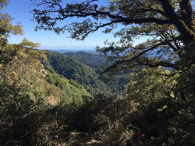
A view of the "canyon" on Coyote Ridge Trail (or as Monta Vista runners like to call it, "Horse" Trail because it's filled with horse manure as with every other major hiking trail around the Bay Area. On a side note, if I were to describe what is the most vivid feeling that reminds me of hiking, it would be the smell of horse-poop. Not even kidding here! - it's actually developed into a nostalgia rather than a inconvenience)

Now, the sun's beginning to set on us. You can see in the horizon - the colors gradually change from a dark blue to a sky blue to a warm, fire-y red.... Another part of evening hiking I like is how the sunlight reflects partially on the trees and creates this strong contrast that you wouldn't get from an afternoon hike....


Pictures of the South bay Shoreline area...

Here, we're getting to the top of Coyote Ridge/Horse Trail. More transmission lines... and the cement plant you can see far above..


In these three photos, what really stands out is the warm, fire-like color of the sun, especially during sunset.

We're finally at the top! Enjoy a nice view of the canyon :)

Since some wild mushrooms grow here, rain/moisture has passed here recently. Turns out, the 2016-2017 rain season had one of the most plentiful precipitation across California, even though it was a La Niña year (supposed to be dry for California, but 2016-17 was an exception).
Another example of the warm color you get on a sunset. From here on, we'll head back towards Stevens Creek Reservoir and back to the roadside.
**Trail routes of all the places I've hiked (Google Maps): https://drive.google.com/open?id=15GpkKZ7JtkH-r1rvxLeR14fcMmo&usp=sharing**
UPDATE - November 21, 2019: Check out my newest brochure I've created for Santa Clara County Parks:


Comments
Post a Comment