Posts

Dec 18, 2016 at Coyote Ridge Trail: Stevens Creek County Park/Fremont Older Open Space Preserve

Image
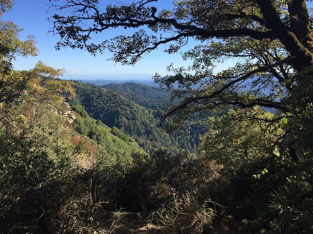
Path Profile of Hike:  HeyWhat'sThat Profile Stats of Hike: Distance  ~3.1 miles out-and-back Elevation Profile:  Max Elevation 1001 ft Min Elevation 440 ft Difference: +561 ft Difficulty: Moderate  Comments on Difficulty: This has a large/considerable elevation gain; fast forward to 2019 I actually ran this hill on a 7 mile run with my high school :-) It was tough in the start, but not so bad later on. Trail Routing  Rim Trail --> Coyote Ridge Trail Parks Covered  Stevens Creek County Park --> MROSD Fremont Older OSP Trail Profile Here's the elevation profile. Yes, that's right, pretty much continuous elevation gain from the side of Stevens Canyon Road up to the peak. There are usually a few turns and switchbacks to ease up the climb, though, so no need to worry about a 45° vertical climb either! I arrived at the park on a sunny, bright afternoon. It was around 5pm - relatively cold, but not bone-chilling. While it was initi

Oct 2, 2016 at Picchetti Ranch Open Space Preserve

Image
Path Profile of Hike:  HeyWhat'sThat Profile Stats of Hike: Distance  ~2.3 miles out-and-back Elevation Profile:  Max Elevation 971 ft Min Elevation 850 ft Difference: +112 ft Difficulty:  Easy  (short hike; small elevation gain) Trail Routing  Zinfandel Trail (named after Zinfandel Wine in CA, perhaps) Parks Covered  MROSD Picchetti Ranch Open Space Preserve Trail Profile Looks like a large elevation gain... from 850 ft to 950 ft.... but is it??? Well, the start is slightly challenging, but it gets relatively flat once you enter the forest. Going up Orchard Loop Trail.... This used to be a wet pond, but due to CA's long 2011-2017 drought, it's doesn't even exist... Looking south, towards Mt. Umunhum. Into the forest! To your front is the Pacific Madrone ( Arbutus menziesii ), commonly known as the refrigerator tree – if you touch its "naked" bark, you can feel how cold it is... A 180° view of the s

Sept 24, 2016 at Castle Rock State Park

Image
Path Profile of Hike:  HeyWhat'sThat Profile  (long URL!) Stats of Hike: Distance  ~3 miles out-and-back then loop, loop intersects with original trail (Saratoga Gap Trail) via Ridge Trail. Elevation Profile:  Max Elevation 3,068 ft Min Elevation 2,602 ft Difference: + 466 ft Difficulty: Moderate (moderately uphill) Trail Routing  Saratoga Gap Trail --> Interconnector Trail --> Ridge Trail --> Saratoga Gap Trail (Parking on Skyline Blvd) Parks Covered  Castle Rock State Park Trail Profile Keep in mind the elevation profile before you go!!! When you park at Skyline, you're actually around the TOP of your hike. As you go, you quickly lose elevation before the ~2 mile mark (at a viewpoint around the rock grove) and slowly climb back up. Since it's downhill then uphill, I would consider this a ~harder "moderate" hike. +/- 466 ft Note the distinct, sandstone formations. The State Park brochure lists this as ~30-40 m

July 19, 2015 (4 years ago!) at Lower Crystal Springs Reservoir

Image
**Trail routes of all the places I've hiked (Google Maps): https://drive.google.com/open?id=15GpkKZ7JtkH-r1rvxLeR14fcMmo&usp=sharing** Going back in time again. How my blog will be structured: I'll post both OLDER and NEWER hikes on this site, and I will make profiles for all of them. Path Profile of Hike:  HeyWhat'sThat Profile  (long URL!) Stats of Hike: Distance  ~6.2 miles out-and-back; mostly flat! Elevation Profile:  Max Elevation 367 ft Min Elevation 272 ft Difference: +95 ft Difficulty: Easy-Moderate (long, but flat hike) Trail Routing  Sawyer Camp Trail; out-and-back Parks Covered  San Francisco Bay Watershed (SF Public Utilities Commission); San Mateo County Parks Trail Profile Here's the elevation map. Note that the hike has a max elevation change of +/- 80ft, so it's mostly a smooth hike.  Starting off... we see some Douglas-fir out in the back... nearby we only have some minor scrubland. As you

Jan 1st, 2018 at Castle Rock State Park

Image
Going back in time..... Here's a fresh start to the 2018 new year (which could apply to 2020 haha), with a nice hike at Sempervirens Point of Castle Rock State Park (see the location data on the side). Some of my posts will be like this, where I just walk you through the hike.... Path Profile of Hike:  HeyWhat'sThat Profile  (sorry, the link is reallllly long!!) Stats of Hike: Distance  ~1.9 miles Elevation Profile:  Max Elevation 2615 ft Min Elevation 2372 ft Difference: +243 ft Difficulty: Easy  ( short distance, moderate elevation gains) Trail Routing  Summit Meadows Trail, then back on Skyline-to-the-Sea Trail Parks Covered  Long Ridge Open Space Preserve, then Castle Rock State Park Trail Profile First, we start off at the  Sempervirens Point  parking lot, and see our first view as we head on the Summit Meadows Trail: We arrived at the afternoon, so the scenery wasn't as clear as it would have been during the morning. H